Weather Data from Tamworth, Staffordshire, UK
 The page of weather data on this web site is taken from a small site near Tamworth,
Staffordshire, UK. The site is in the garden of a house on a large
housing estate.
The page of weather data on this web site is taken from a small site near Tamworth,
Staffordshire, UK. The site is in the garden of a house on a large
housing estate.
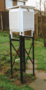
The Stevenson screen on the left contains some of the weather instruments. We make no claim for accuracy, as the data is collected as a hobby. It is placed on this Website for other people’s interest and amusement. However we do hope that the data provided is still useful.
The data is collected each day at 9.00 GMT. Some data is also collected remotely.
See more about setting up a Stevenson screen on the Setting up your Weather Station page.
Explanation of features on the data chart
Date - This is recorded in the first column.
Max. T. - The highest temperature for the last 24 hours.
Min. T. - The lowest temperature for the last 24 hours.
Dry T. - The dry temperature.
Wet T. - The wet temperature.
Hum. - The humidity calculated from the dry and wet temperatures.
Press. - The air pressure reading in mB.
Wind D. - The wind direction.
Wind St. - The wind strength as measured on the Beaufort Scale.
Cl.am. - The amount of cloud cover, measured in Octas.
Cl.Ty. The main types of cloud.
C. Clear of cloud
Ci. Cirrus
Cc. Cirrocumulus
Cs. Cirrostratus
Ac. Altocumulus
As. Altostratus
Ns. Nimbostratus
Sc. Stratocumulus
St. Stratus
Cu. Cumulus
Cb. Cumulonimbus
Rain - The amount of rain collected in a rain gauge for the past 24 hours. This
is measured in mm. (T = total rainfall)
Snow - The height of snow, measured in cm.
Ave. - This is the average.
Max. - This is the maximum.
Min. - This is the minimum.